Hydrogeology
Water, Springs and Mine-Water Pathways
In a historic mining district, the question is not how far apart two points are on the surface. It is whether they are connected underground.
Reported observations — this catchment only
What people report at the stream
These are local reports from the Troon, Carwynnen and Holmans catchment. They are recorded as reported observations and are not treated as established findings until sampling and laboratory analysis are carried out.
Strong sulphur smell at stream point 3
A strong sulphur-like odour is reported at stream point 3, described alongside a metallic character to the water. Odour can indicate reducing conditions or sulphide chemistry; on its own it identifies neither a source nor a contaminant.
Sulphur smell in the air
Sulphur-like odour is also reported in the air locally, at times and in places that have not yet been systematically logged. Date, time, wind direction and location are the missing records needed before any pattern can be tested.
Borehole testing reported unaffected
Water borehole tests carried out locally are reported as not showing an effect. That is relevant information: deep borehole supply and shallow surface-water pathways can behave very differently, so one result does not answer the other question.
Nothing here attributes a cause. The purpose is to record what is reported, where, so it can be sampled properly. If you have observed odour or discolouration in this catchment, record it on the observation form.
Water imagery
What water evidence looks like on the ground
Visual material relevant to the water question: the joint structure that controls where granite transmits water, and the reported corridor between the woodland and the facility area.
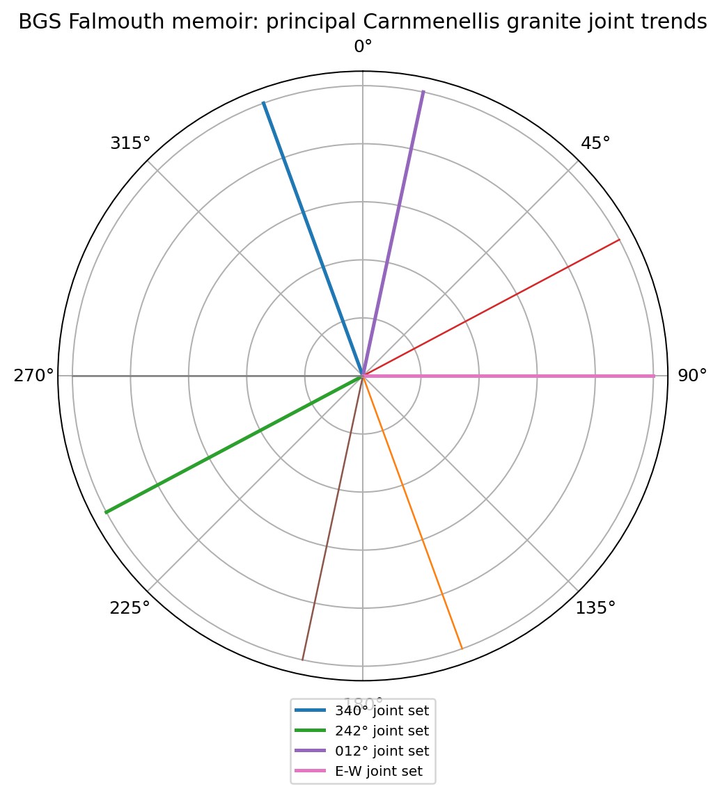
Principal Carnmenellis granite joint trends
Rose diagram of the principal joint sets recorded in the Carnmenellis granite: approximately 340°, 242°, 012° and an east–west set.
What this does and does not show: Jointing controls where granite can transmit water and where energy can travel. These orientations are the reason the investigation asks whether effects are aligned with structure rather than randomly distributed.
Source: BGS Falmouth memoir, summarised in the geology & hydrogeology report
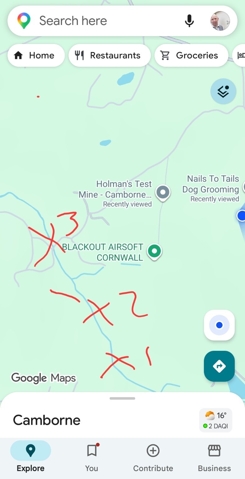
Reported X1–X3 corridor annotation
Mapping annotated by hand with points marked X1, X2 and X3 forming a corridor between the Carwynnen woodland and the facility area.
What this does and does not show: The X1–X3 marks are a reported corridor of interest, not measured sampling stations. Their purpose is to tell surveyors where to look first, not to assert that anything has been found.
Source: Community-supplied annotated mapping, reproduced in the master dossier
Intact granite has relatively low matrix permeability: water does not move easily through the body of the rock itself. That fact is often used, incorrectly, to argue that groundwater cannot travel far.
In historic mining districts, groundwater movement is instead dominated by secondary permeability — the openings created by geology and by three centuries of mining:
- Fractures
- Joints
- Mineral veins and lodes
- Shafts
- Adits and drainage levels
- Stopes
- Tunnels
- Flooded workings
- Artificial drainage routes
These features can transmit water rapidly and over distances that bear no simple relationship to surface geography. Water can also move in directions that surface topography would not predict.
The investigation must therefore examine underground connections rather than simply surface distance. Establishing or excluding connectivity is a hydrogeological question, answered by mine plans, water-level monitoring, hydrochemistry and, where justified, tracer testing.
Conceptual pathways
Routes that must be tested, not assumed
The following are conceptual pathways only. Each is a working hypothesis requiring hydrogeological investigation. None is asserted to be occurring.
Rainfall to spring
- 1Rainfall infiltrates the soil and weathered zone
- 2Water enters fracture and joint networks
- 3Flow intercepts a historic mine working
- 4Water moves through the flooded workings
- 5Groundwater re-emerges at a spring line
Conceptual pathway requiring investigation. Whether any such connection exists in this location is not established.
Mine-water to stream
- 1Water standing in historic workings
- 2Movement along a fracture or vein system
- 3Discharge to a drainage level or seepage point
- 4Entry to a surface watercourse
Conceptual pathway requiring investigation. Mine-water discharge to watercourses is well documented across Cornwall generally; its occurrence at any specific point here is unverified.
Altered groundwater to woodland
- 1A change in groundwater level or chemistry
- 2Altered saturation in the shallow soil profile
- 3Stress or decay affecting the fine-root zone
- 4Reduced anchorage and tree health decline
Conceptual pathway requiring investigation, linking hydrogeology to the tree-failure question. Not established.
Water evidence
How water testing is recorded here
Water results are only meaningful with their context. Every result published on this site carries the information needed to judge it.
Historic water tests
Awaiting verificationAny pre-existing test results held by residents, landowners, Environmental Health or previous owners. These are the closest thing to a baseline the area has, and are actively sought.
Current water tests
Awaiting verificationSamples taken now, at defined points, by a stated person, using a stated method, analysed by a named laboratory.
Control samples
Awaiting verificationSamples from comparable sources outside the area of concern. Without controls, no result can be interpreted as unusual.
Analytical suite
Determinands under consideration
The suite below reflects the geology of the district and the receptors present. Final scheduling should be set by an environmental geochemist and, where relevant, an explosives-residue chemist.
pH
Field and laboratory pH; mine-influenced water can be acidic or neutral.
Electrical conductivity
A rapid indicator of total dissolved ion content.
ORP / redox potential
Indicates oxidising or reducing conditions in the source.
Sulphate
Commonly elevated where sulphide minerals are oxidising.
Iron
Responsible for the familiar orange staining of mine-influenced water.
Manganese
Often accompanies iron; has its own drinking-water standard.
Arsenic
Naturally associated with Cornish mineralisation; requires careful comparison.
Lead
Can arise from mineralisation, historic processing or plumbing.
Copper
A principal historic ore metal of the district.
Zinc
Frequently mobilised with other base metals.
Cadmium
Often present with zinc mineralisation at trace levels.
Nitrate
Primarily agricultural; important as a control on interpretation.
Nitrite
Indicates incomplete nitrification or other processes.
Ammonium
Agricultural, organic or, in specific cases, energetic-material related.
Energetic / pyrotechnic compounds
Specialist determinands only where professionally indicated, using an accredited laboratory with appropriate methods and detection limits.
Evidence status
Water: where this stands
Secondary permeability dominates
That groundwater flow in fractured, historically mined granite terrain is dominated by fractures, veins and mine voids rather than rock matrix is established hydrogeological understanding, reflected in published BGS and mine-water literature.
Changes to springs and streams
Residents report changes in flow, colour, sediment or odour at particular sources. These reports are logged, but none has yet been supported by paired sampling with controls.
Underground connectivity
That specific springs or watercourses are hydraulically connected to particular underground features is a hypothesis testable by water-level monitoring, hydrochemistry and tracer testing.
Any contaminant pathway
No demonstrated contaminant pathway from any operation to any water receptor exists on the present evidence. Establishing or excluding one is a task for independent specialists.